Tiedosto:Bodie is a ghost town in the Bodie Hills east of the Sierra Nevada mountain range in Mono County, California LCCN2013632886.tif
Alkuperäinen tiedosto (7 360 × 4 912 kuvapistettä, 206,9 MiB, MIME-tyyppi: image/tiff)
Tämä tiedosto on tiedostotietokanta Wikimedia Commonsista. Tiedot kuvaussivulta näkyvät alla. | Tiedoston kuvaussivu Commonsissa |
Yhteenveto
KuvausBodie is a ghost town in the Bodie Hills east of the Sierra Nevada mountain range in Mono County, California LCCN2013632886.tif |
English: Title: Bodie is a ghost town in the Bodie Hills east of the Sierra Nevada mountain range in Mono County, California
Physical description: 1 photograph : digital, tiff file, infrared. Notes: Title, date, and keywords provided by the photographer.; Credit line: The Jon B. Lovelace Collection of California Photographs in Carol M. Highsmith's America Project, Library of Congress, Prints and Photographs Division.; Gift; The Capital Group Companies Charitable Foundation in memory of Jon B. Lovelace; 2012; (DLC/PP-2012:063).; Forms part of: Jon B. Lovelace Collection of California Photographs in Carol M. Highsmith's America Project in the Carol M. Highsmith Archive.; Located about 75 miles southeast of Lake Tahoe, the town become a state historic park in 1962. |
||||||||||||||||||||||||||
Päiväys | Kuvattu 23. heinäkuuta 2012, 12:24 (Exif-tietojen mukaan) | ||||||||||||||||||||||||||
Lähde |
Library of Congress
|
||||||||||||||||||||||||||
Tekijä |
creator QS:P170,Q5044454 |
||||||||||||||||||||||||||
Käyttöoikeus (Tämän tiedoston uudelleenkäyttö) |
No known restrictions on publication.
|
Kameran sijainti | 38° 12′ 42,03″ N, 119° 00′ 45,32″ W | Tämä ja muut kuvat kartalla: OpenStreetMap | 38.211675; -119.012588 |
---|
Lisenssi
Public domainPublic domainfalsefalse |
This work is from the Carol M. Highsmith Archive collection at the Library of Congress. According to the library, there are no known copyright restrictions on the use of this work. Carol M. Highsmith has stipulated that her photographs are in the public domain. Photographs of sculpture or other works of art may be restricted by the copyright of the artist; see Commons:FOP US#Artworks and sculptures for more information. |
Kohteet, joita tässä tiedostossa esitetään
esittää
2012
38°12'42.030"N, 119°0'45.317"W
image/tiff
ffef5a17ce9bdccdad03e19fce9728b71bfb3ed9
216 952 658 tavu
4 912 pikseli
7 360 pikseli
Tiedoston historia
Päiväystä napsauttamalla näet, millainen tiedosto oli kyseisellä hetkellä.
Päiväys | Pienoiskuva | Koko | Käyttäjä | Kommentti | |
---|---|---|---|---|---|
nykyinen | 24. syyskuuta 2016 kello 07.18 | 
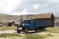
7 360 × 4 912 (206,9 MiB) | Fæ | LOC 2013632886, Carol M. Highsmith collection. P5391.20195 TIFF (206.9mb) |
Tiedoston käyttö
Seuraava sivu käyttää tätä tiedostoa:
Metatieto
Tämä tiedosto sisältää esimerkiksi kuvanlukijan, digikameran tai kuvankäsittelyohjelman lisäämiä lisätietoja. Kaikki tiedot eivät enää välttämättä vastaa todellisuutta, jos kuvaa on muokattu sen alkuperäisen luonnin jälkeen.
Kuvan nimi | Bodie is a ghost town in the Bodie Hills east of the Sierra Nevada mountain range in Mono County, California, United States, about 75 miles (120 km) southeast of Lake Tahoe. It is located 12 miles (19 km) east-southeast of Bridgeport,at an elevation of 8379 feet (2554 m). As Bodie Historic District, the U.S. Department of the Interior recognizes it as a National Historic Landmark. The ghost town had been administered by California State Parks since becoming a state historic park in 1962, and receives about 200,000 visitors yearly |
---|---|
Kameran valmistaja | NIKON CORPORATION |
Kameran malli | NIKON D800 |
Tekijä | Photographer: Carol M. Highsmith |
Valotusaika | 1/125 s (0,008) |
Aukkosuhde | f/10 |
Herkkyys (ISO) | 100 |
Luontipäivämäärä | 23. heinäkuuta 2012 kello 12.24 |
Linssin polttoväli | 60 mm |
Leveysaste | 38° 12′ 42,03″ N |
Pituusaste | 119° 0′ 45,32″ W |
Korkeus | 2 557 metriä merenpinnan yläpuolella |
Leveys | 7 360 px |
Korkeus | 4 912 px |
Bittiä komponentissa |
|
Pakkaustapa | Pakkaamaton |
Kuvapisteen koostumus | RGB |
Kuvatiedon sijainti | 36 130 |
Suunta | Normaali |
Komponenttien lukumäärä | 3 |
Kaistan rivien lukumäärä | 4 912 |
Tavua pakatussa kaistassa | 216 913 920 |
Kuvan resoluutio leveyssuunnassa | 300 dpi |
Kuvan resoluutio korkeussuunnassa | 300 dpi |
Tiedon järjestely | kokkaremuoto |
Käytetty ohjelmisto | Ver.1.00 |
Viimeksi muokattu | 4. elokuuta 2012 kello 22.46 |
Valotusohjelma | Käsinsäädetty |
Exif-versio | 2.21 |
Digitointipäivämäärä | 23. heinäkuuta 2012 kello 12.24 |
APEX-suljinaika | 6,965784 |
APEX-aukko | 6,643856 |
Valotuksen korjaus | 0 |
Suurin aukko | 3 APEX (f/2,83) |
Mittaustapa | Kuvio |
Valolähde | Tuntematon |
Salama | Salama ei lauennut, salamavalo estetty |
Luontiaikaleiman sekunninosat | 4 |
Digitointiaikaleiman sekunninosat | 4 |
Väriavaruus | Kalibroimaton |
Tarkennustason X-resoluutio | 204,84020996094 |
Tarkennustason Y-resoluutio | 204,84020996094 |
Tarkennustason resoluution yksikkö | 4 |
Mittausmenetelmä | Yksisiruinen värikenno |
Tiedostolähde | Digitaalikamera |
Kuvatyyppi | Suoraan valokuvattu kuva |
Muokattu kuvankäsittely | Normaali käsittely |
Valotustapa | Käsinsäädetty valotus |
Valkotasapaino | Automaattinen valkotasapaino |
Digitaalinen suurennoskerroin | 1 |
35 mm:n filmiä vastaava polttoväli | 60 mm |
Kuvan kaappaustapa | Perus |
Kuvasäätö | Ei ole |
Kontrasti | Normaali |
Värikylläisyys | Normaali |
Terävyys | Normaali |
Kohteen etäisyysväli | Tuntematon |
GPS-aika (atomikello) | 20.24 |
Mittaukseen käytetyt satelliitit | 08 |
Käytetty geodeettinen maanmittaustieto | WGS 84 |
GPS-päivämäärä | 23. heinäkuuta 2012 |
GPS-muotoilukoodin versio | 2.3.0.0 |