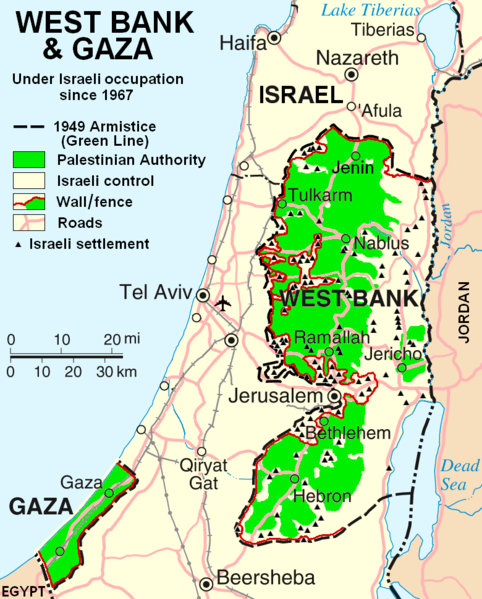
Tiedosto:West Bank & Gaza Map 2007 (Settlements).png
Siirry navigaatioon
Siirry hakuun

Tämän esikatselun koko: 482 × 599 kuvapistettä. Muut resoluutiot: 193 × 240 kuvapistettä | 386 × 480 kuvapistettä | 780 × 970 kuvapistettä.
Alkuperäinen tiedosto (780 × 970 kuvapistettä, 86 KiB, MIME-tyyppi: image/png)
Tiedoston historia
Päiväystä napsauttamalla näet, millainen tiedosto oli kyseisellä hetkellä.
| Päiväys | Pienoiskuva | Koko | Käyttäjä | Kommentti | |
|---|---|---|---|---|---|
| nykyinen | 30. lokakuuta 2013 kello 00.55 |  | 780 × 970 (86 KiB) | Hex | Correct capitalization in legend. |
| 30. lokakuuta 2013 kello 00.54 |  | 780 × 970 (86 KiB) | Hex | Correct capitalization in legend. | |
| 12. tammikuuta 2009 kello 08.21 |  | 780 × 970 (105 KiB) | HowardMorland | Replace .gif file with identical .png file <!--{{ImageUpload|basic}}--> |
Tiedoston käyttö
Seuraava sivu käyttää tätä tiedostoa:
Tiedoston järjestelmänlaajuinen käyttö
Seuraavat muut wikit käyttävät tätä tiedostoa:
- Käyttö sivustolla am.wikipedia.org
- Käyttö sivustolla ar.wikipedia.org
- Käyttö sivustolla ast.wikipedia.org
- Käyttö sivustolla azb.wikipedia.org
- Käyttö sivustolla bg.wikipedia.org
- Käyttö sivustolla ca.wikipedia.org
- Käyttö sivustolla ckb.wikipedia.org
- Käyttö sivustolla cs.wikipedia.org
- Käyttö sivustolla cy.wikipedia.org
- Käyttö sivustolla da.wikipedia.org
- Käyttö sivustolla de.wikipedia.org
- Käyttö sivustolla de.wikinews.org
- Käyttö sivustolla de.wikivoyage.org
- Käyttö sivustolla en.wikipedia.org
- List of cities administered by the Palestinian Authority
- Talk:List of ongoing armed conflicts
- User:Timeshifter/Userboxes
- User:Gimmetrow/test
- User:Gimmetrow/test2
- Talk:Jerusalem/Archive 15
- Talk:Palestinian Authority/Archive 2
- File talk:West Bank & Gaza Map 2007 (Settlements).png
- Wikipedia:Top 25 Report/July 13 to 19, 2014
- Wikipedia:Top 25 Report/July 20 to 26, 2014
- Wikipedia:Top 25 Report/July 27 to August 2, 2014
- Talk:State of Palestine/Archive 12
- User:Timeshifter/Userboxes/Palestine: Peace Not Apartheid. By Jimmy Carter
- User:TheSouthernIrishman
- User:Dare2Leap/info
- User:Timeshifter/Archive 2
- Wikipedia talk:WikiProject Israel Palestine Collaboration/Archive 9
- Käyttö sivustolla en.wikinews.org
- Käyttö sivustolla eo.wikipedia.org
- Käyttö sivustolla es.wikipedia.org
- Käyttö sivustolla eu.wikipedia.org
- Käyttö sivustolla fa.wikipedia.org
- Käyttö sivustolla fo.wikipedia.org
- Käyttö sivustolla fr.wikipedia.org
Näytä lisää tämän tiedoston järjestelmänlaajuista käyttöä.
