
Tiedosto:Sweden.1985.coalition.largest.map.svg

Tämän PNG-esikatselun koko koskien SVG-tiedostoa: 266 × 600 kuvapistettä. Muut resoluutiot: 106 × 240 kuvapistettä | 213 × 480 kuvapistettä | 340 × 768 kuvapistettä | 454 × 1 024 kuvapistettä | 908 × 2 048 kuvapistettä | 290 × 654 kuvapistettä.
Alkuperäinen tiedosto (SVG-tiedosto; oletustarkkuus 290 × 654 kuvapistettä; tiedostokoko 276 KiB)
| Tämä tiedosto on tiedostotietokanta Wikimedia Commonsista. Tiedot kuvaussivulta näkyvät alla. |  |
Tiedoston kuvaussivu Commonsissa |
Yhteenveto
| Kuvaus |
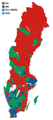
English: Map of municipalities of Sweden (borders of 2006) showing votes in the Swedish general election of 1985. Each municipality has the color of the party that got the most votes within the coalition that won relative majority. |
| Päiväys | |
| Lähde | Original borders of the map come from Statistics Sweden (SCB). SVG-file 'skeleton' by Lokal_Profil. Election results from Statistics Sweden (SCB). |
| Tekijä | Skogssvinet |
Lisenssi
Minä, tämän teoksen tekijänoikeuksien haltija, julkaisen täten tämän teoksen seuraavalla lisenssillä:
Tämä tiedosto on lisensoitu Creative Commons Nimeä-JaaSamoin 3.0 Ei sovitettu -lisenssillä.
- Voit:
- jakaa – kopioida, levittää ja esittää teosta
- remiksata – valmistaa muutettuja teoksia
- Seuraavilla ehdoilla:
- nimeäminen – Sinun on mainittava lähde asianmukaisesti, tarjottava linkki lisenssiin sekä merkittävä, mikäli olet tehnyt muutoksia. Voit tehdä yllä olevan millä tahansa kohtuullisella tavalla, mutta et siten, että annat ymmärtää lisenssinantajan suosittelevan sinua tai teoksen käyttöäsi.
- jaa samoin – Jos muutat tai perustat tähän työhön, voit jakaa tuloksena syntyvää työtä vain tällä tai tämän kaltaisella lisenssillä.
Tiedoston historia
Päiväystä napsauttamalla näet, millainen tiedosto oli kyseisellä hetkellä.
| Päiväys | Pienoiskuva | Koko | Käyttäjä | Kommentti | |
|---|---|---|---|---|---|
| nykyinen | 7. helmikuuta 2009 kello 07.37 | | 290 × 654 (276 KiB) | Skogssvinet | |
| 28. tammikuuta 2009 kello 07.32 |  | 290 × 654 (276 KiB) | Skogssvinet | {{Information |Description={{en|1=Map of municipalities of Sweden (borders of 2006) showing votes in the Swedish general election of 1985. Each municipality has the color of the party that got the most votes <i>within</i> the coalition that won relative m |
Tiedoston käyttö
Seuraava sivu käyttää tätä tiedostoa:
Tiedoston järjestelmänlaajuinen käyttö
Seuraavat muut wikit käyttävät tätä tiedostoa:
- Käyttö sivustolla en.wikipedia.org
- Käyttö sivustolla fr.wikipedia.org