Tiedosto:New York state geographic map-en.svg

Alkuperäinen tiedosto (SVG-tiedosto; oletustarkkuus 2 811 × 2 000 kuvapistettä; tiedostokoko 18,34 MiB)
| Tämä tiedosto on tiedostotietokanta Wikimedia Commonsista. Tiedot kuvaussivulta näkyvät alla. |  |
Tiedoston kuvaussivu Commonsissa |
Yhteenveto
| Kuvailu |
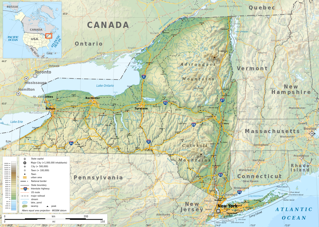
English: Geographic map of New York state in English. Geographic limits of the map:
|
| Päiväys | |
| Lähde |
Oma teos
|
| Tekijä | |
| Käyttöoikeus (Tämän tiedoston uudelleenkäyttö) |
Any use of this map is subject of the license(s) stated below with the condition that you credit (Wikimedia Commons user: Ikonact) as the author . A message with a reply address would also be greatly appreciated. |
| Georeferointi | If inappropriate please set warp_status = skip to hide. |
|

|
Tässä SVG-tiedostossa on tekstiä, jonka voi kääntää helposti suomen kielelle käyttäen SVG-editoria kuten Inkscapea tai Adobe Illustratoria. Lisätietoja on sivulla Commons:Translation possible/Learn more. Voit myös ladata ja tallentaa sen, ja kääntää sen manuaalisesti tekstimuokkaimella. |
Lisenssi
| This work contains information from OpenStreetMap, which is made available under the Open Database License (ODbL).
The ODbL does not require any particular license for maps produced from ODbL data. Prior to 1 August 2020, map tiles produced by the OpenStreetMap Foundation were licensed under the CC-BY-SA-2.0 license. Maps produced by other people may be subject to other licences. |
- Voit:
- jakaa – kopioida, levittää ja esittää teosta
- remiksata – valmistaa muutettuja teoksia
- Seuraavilla ehdoilla:
- nimeäminen – Sinun on mainittava lähde asianmukaisesti, tarjottava linkki lisenssiin sekä merkittävä, mikäli olet tehnyt muutoksia. Voit tehdä yllä olevan millä tahansa kohtuullisella tavalla, mutta et siten, että annat ymmärtää lisenssinantajan suosittelevan sinua tai teoksen käyttöäsi.
- jaa samoin – Jos muutat tai perustat tähän työhön, voit jakaa tuloksena syntyvää työtä vain tällä tai tämän kaltaisella lisenssillä.
Tiedoston historia
Päiväystä napsauttamalla näet, millainen tiedosto oli kyseisellä hetkellä.
| Päiväys | Pienoiskuva | Koko | Käyttäjä | Kommentti | |
|---|---|---|---|---|---|
| nykyinen | 2. marraskuuta 2023 kello 15.15 | | 2 811 × 2 000 (18,34 MiB) | Ikonact | corrected some typos in names // Editing SVG source code using c:User:Rillke/SVGedit.js |
| 14. lokakuuta 2019 kello 13.22 |  | 2 811 × 2 000 (18,41 MiB) | Ikonact | better dealing with fall back font | |
| 13. lokakuuta 2019 kello 00.19 |  | 2 811 × 2 000 (20,53 MiB) | Ikonact | + fall back font, more towns and islands, provinces | |
| 12. lokakuuta 2019 kello 02.33 |  | 2 811 × 2 000 (20,47 MiB) | Ikonact | error corrected | |
| 12. lokakuuta 2019 kello 02.23 |  | 2 811 × 2 000 (20,47 MiB) | Ikonact | river and lake names added | |
| 9. lokakuuta 2019 kello 00.58 |  | 2 811 × 2 000 (20,33 MiB) | Ikonact | some improvements, roads and cities in Canada | |
| 22. syyskuuta 2019 kello 10.40 |  | 2 811 × 2 000 (14,39 MiB) | Ikonact | small corrections | |
| 21. syyskuuta 2019 kello 23.49 |  | 2 811 × 2 000 (14,39 MiB) | Ikonact | + road names | |
| 21. syyskuuta 2019 kello 23.23 |  | 2 811 × 2 000 (14,31 MiB) | Ikonact | +names | |
| 21. syyskuuta 2019 kello 01.01 |  | 2 811 × 2 000 (15,37 MiB) | Ikonact | == {{int:filedesc}} == {{Information |description={{en|1=Geographic map of New York state in English. Geographic limits of the map:}} *N: 45.30° N *S: 40.30° N *W: 80.20° W *E: 71.00° W Albers equal area projection; WGS 84 datum |date=2019-09-21 |source={{own}} *Sources of data:<br/> **Topography: ETOPO1 (public domain);<br/> **Public domain data provided by the National Atlas of the United States of America;<br/> *Tool:<br/> **The map is created with Octave scripts d... |
Tiedoston käyttö
Tätä tiedostoa ei käytetä millään sivulla.
Tiedoston järjestelmänlaajuinen käyttö
Seuraavat muut wikit käyttävät tätä tiedostoa:
- Käyttö kohteessa af.wikipedia.org
- Käyttö kohteessa ang.wikipedia.org
- Käyttö kohteessa az.wikipedia.org
- Käyttö kohteessa be.wikipedia.org
- Käyttö kohteessa bg.wikipedia.org
- Käyttö kohteessa bn.wikipedia.org
- Käyttö kohteessa ca.wikipedia.org
- Käyttö kohteessa en.wikipedia.org
- Käyttö kohteessa eo.wikipedia.org
- Käyttö kohteessa fr.wikipedia.org
- Käyttö kohteessa ga.wikipedia.org
- Käyttö kohteessa gl.wikipedia.org
- Käyttö kohteessa ha.wikipedia.org
- Käyttö kohteessa hu.wikipedia.org
- Käyttö kohteessa hy.wikipedia.org
- Käyttö kohteessa id.wikipedia.org
- Käyttö kohteessa lt.wikipedia.org
- Käyttö kohteessa mhr.wikipedia.org
- Käyttö kohteessa ml.wikipedia.org
- Käyttö kohteessa os.wikipedia.org
- Käyttö kohteessa pcd.wikipedia.org
- Käyttö kohteessa pl.wikipedia.org
- Käyttö kohteessa sh.wikipedia.org
- Käyttö kohteessa tg.wikipedia.org
- Käyttö kohteessa tr.wikipedia.org
- Käyttö kohteessa tt.wikipedia.org
- Käyttö kohteessa uk.wikipedia.org
- Käyttö kohteessa www.wikidata.org