Tiedosto:NUTS 3 regions of the East of England 2010 map.svg
Siirry navigaatioon
Siirry hakuun

Tämän PNG-esikatselun koko koskien SVG-tiedostoa: 573 × 600 kuvapistettä. Muut resoluutiot: 229 × 240 kuvapistettä | 459 × 480 kuvapistettä | 734 × 768 kuvapistettä | 979 × 1 024 kuvapistettä | 1 957 × 2 048 kuvapistettä | 1 210 × 1 266 kuvapistettä.
Alkuperäinen tiedosto (SVG-tiedosto; oletustarkkuus 1 210 × 1 266 kuvapistettä; tiedostokoko 2,17 MiB)
| Tämä tiedosto on tiedostotietokanta Wikimedia Commonsista. Tiedot kuvaussivulta näkyvät alla. |  |
Tiedoston kuvaussivu Commonsissa |
Yhteenveto
| Kuvaus |
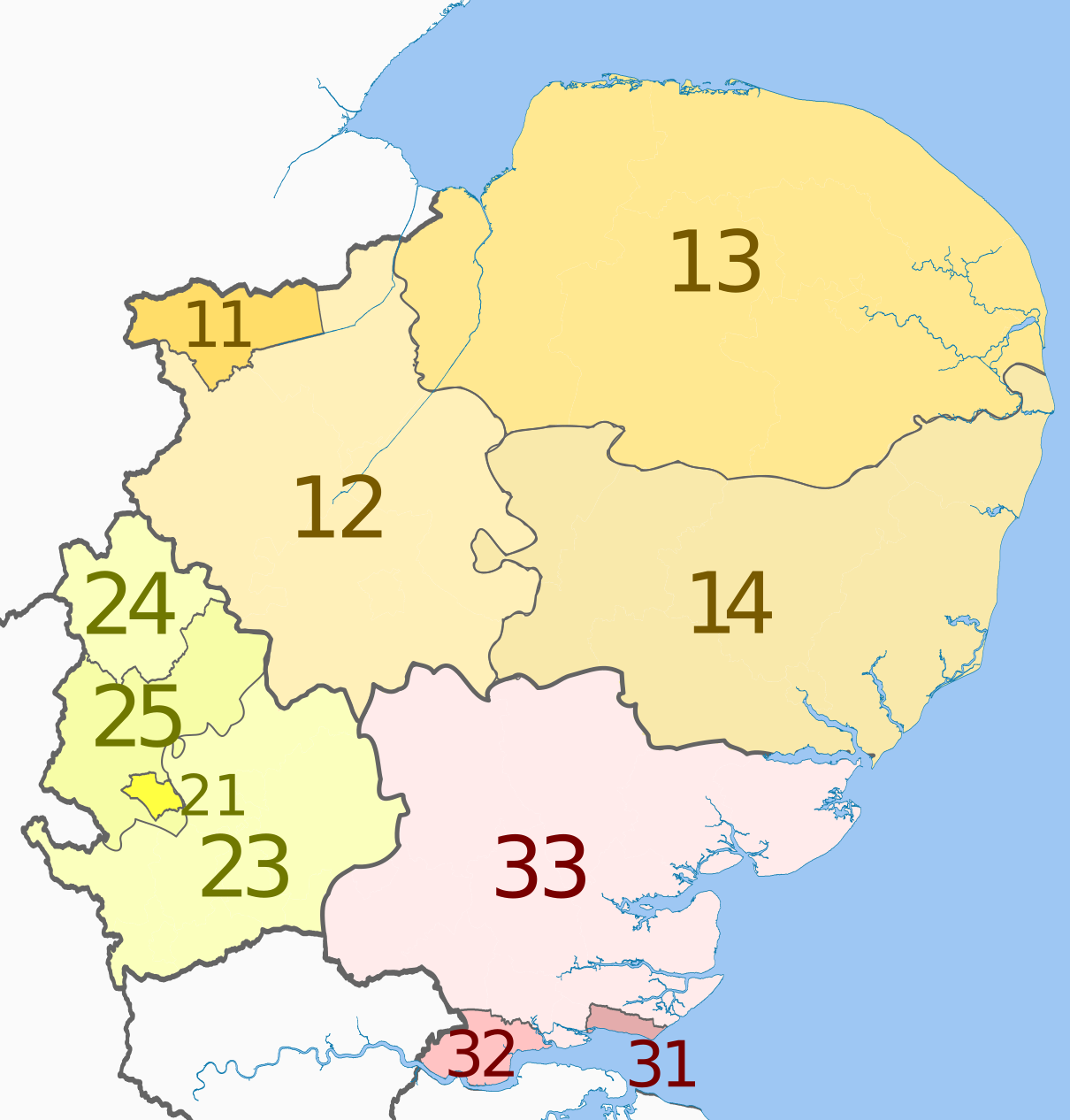
English: Map of the NUTS 3 regions of the East of England, from 2010.
Equirectangular map projection on WGS 84 datum, with N/S stretched 160% Geographic limits:
|
| Päiväys | (UTC) |
| Lähde |
Tämä tiedosto on johdettu tiedostosta: |
| Tekijä |
|
| Muut versiot | File:NUTS 3 regions of the East of England map.svg, former regions until 2010. |


| NUTS 1 | Code | NUTS 2 | Code | NUTS 3 | Code |
|---|---|---|---|---|---|
| East of England | UKH | East Anglia | UKH1 | Peterborough | UKH11 |
| Cambridgeshire CC | UKH12 | ||||
| Norfolk | UKH13 | ||||
| Suffolk | UKH14 | ||||
| Bedfordshire and Hertfordshire | UKH2 | Luton | UKH21 | ||
| Hertfordshire CC | UKH23 | ||||
| Bedford | UKH24 | ||||
| Central Bedfordshire | UKH25 | ||||
| Essex | UKH3 | Southend-on-Sea | UKH31 | ||
| Thurrock | UKH32 | ||||
| Essex CC | UKH33 |
Lisenssi
Tämä tiedosto on lisensoitu Creative Commons Nimeä-JaaSamoin 3.0 Ei sovitettu -lisenssillä.
Nimeä: Dr Greg and Nilfanion. Contains Ordnance Survey data © Crown copyright and database right 2011
- Voit:
- jakaa – kopioida, levittää ja esittää teosta
- remiksata – valmistaa muutettuja teoksia
- Seuraavilla ehdoilla:
- nimeäminen – Sinun on mainittava lähde asianmukaisesti, tarjottava linkki lisenssiin sekä merkittävä, mikäli olet tehnyt muutoksia. Voit tehdä yllä olevan millä tahansa kohtuullisella tavalla, mutta et siten, että annat ymmärtää lisenssinantajan suosittelevan sinua tai teoksen käyttöäsi.
- jaa samoin – Jos muutat tai perustat tähän työhön, voit jakaa tuloksena syntyvää työtä vain tällä tai tämän kaltaisella lisenssillä.
Alkuperäinen tallennusloki
This image is a derivative work of the following images:
- File:East_of_England_districts_2011_map.svg licensed with Cc-by-sa-3.0, GFDL
- 2011-05-01T18:51:41Z Nilfanion 1210x1266 (2248752 Bytes) {{Information |Description=Map of the [[w:East of England|East of England]] region showing the administrative districts. Equirectangular map projection on WGS 84 datum, with N/S stretched 160% Geographic limits: *West: 0.8W
- File:English_ceremonial_counties_2010.svg licensed with Cc-by-sa-3.0, GFDL
- 2010-11-23T16:39:55Z Nilfanion 1108x1345 (308868 Bytes) thicker lines
- 2010-11-23T16:20:19Z Nilfanion 1108x1345 (301520 Bytes) tweaks
- 2010-10-26T20:34:20Z Nilfanion 817x990 (1391832 Bytes) {{Information |Description=Map showing the [[w:ceremonial counties of England]] including the City of London, in 2010. Equirectangular map projection on WGS 84 datum, with N/S stretched 170% Geographic limits: *West: 6.75W
Uploaded with derivativeFX
Tiedoston historia
Päiväystä napsauttamalla näet, millainen tiedosto oli kyseisellä hetkellä.
| Päiväys | Pienoiskuva | Koko | Käyttäjä | Kommentti | |
|---|---|---|---|---|---|
| nykyinen | 22. lokakuuta 2012 kello 00.36 | | 1 210 × 1 266 (2,17 MiB) | Dr Greg | == {{int:filedesc}} == {{Information |Description={{en|Map of the NUTS 3 regions of the East of England, from 2010. Equirectangular map projection on WGS 84 datum, with N... |
Tiedoston käyttö
Seuraava sivu käyttää tätä tiedostoa:
Tiedoston järjestelmänlaajuinen käyttö
Seuraavat muut wikit käyttävät tätä tiedostoa:
- Käyttö kohteessa de.wikipedia.org
- Käyttö kohteessa en.wikipedia.org
- Käyttö kohteessa it.wikipedia.org
- Käyttö kohteessa lt.wikipedia.org