Tiedosto:MarethMap1943.png
Siirry navigaatioon
Siirry hakuun

Tämän esikatselun koko: 800 × 572 kuvapistettä. Muut resoluutiot: 320 × 229 kuvapistettä | 640 × 457 kuvapistettä | 1 024 × 732 kuvapistettä | 1 170 × 836 kuvapistettä.
Alkuperäinen tiedosto (1 170 × 836 kuvapistettä, 236 KiB, MIME-tyyppi: image/png)
| Tämä tiedosto on tiedostotietokanta Wikimedia Commonsista. Tiedot kuvaussivulta näkyvät alla. |  |
Tiedoston kuvaussivu Commonsissa |
Yhteenveto
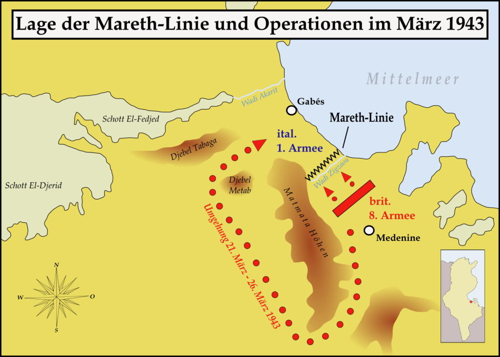
| Kuvaus | Map showing the situation of the Mareth line and the British attacks on it during March 1943 |
| Päiväys | |
| Lähde | Oma teos |
| Tekijä | Memnon335bc |
Lisenssi
Minä, tämän teoksen tekijänoikeuksien haltija, julkaisen täten tämän teoksen seuraavilla lisensseillä:

|
Voit kopioida, levittää ja/tai muuttaa tätä asiakirjaa GNU Free Documentation License -lisenssin version 1.2 tai minkä tahansa Free Software Foundationin julkaiseman myöhemmän version ehtojen alaisena; ei koske muuttumattomia kohtia, etukannen tekstejä eikä takakannen tekstejä. Kopio tästä lisenssistä on saatavilla osiossa GNU Free Documentation License. |
This file is licensed under the Creative Commons Attribution-Share Alike Attribution-Share Alike 4.0 International, 3.0 Unported, 2.5 Generic, 2.0 Generic and 1.0 Generic license.
- Voit:
- jakaa – kopioida, levittää ja esittää teosta
- remiksata – valmistaa muutettuja teoksia
- Seuraavilla ehdoilla:
- nimeäminen – Sinun on mainittava lähde asianmukaisesti, tarjottava linkki lisenssiin sekä merkittävä, mikäli olet tehnyt muutoksia. Voit tehdä yllä olevan millä tahansa kohtuullisella tavalla, mutta et siten, että annat ymmärtää lisenssinantajan suosittelevan sinua tai teoksen käyttöäsi.
- jaa samoin – Jos muutat tai perustat tähän työhön, voit jakaa tuloksena syntyvää työtä vain tällä tai tämän kaltaisella lisenssillä.
Voit valita haluamasi lisenssin.
Tiedoston historia
Päiväystä napsauttamalla näet, millainen tiedosto oli kyseisellä hetkellä.
| Päiväys | Pienoiskuva | Koko | Käyttäjä | Kommentti | |
|---|---|---|---|---|---|
| nykyinen | 27. maaliskuuta 2008 kello 15.02 | | 1 170 × 836 (236 KiB) | Memnon335bc | {{Information |Description=Map showing the situation of the Mareth line and the Brith attacks on it during March 1943 |Source=self-made |Date=March 2008 |Author= Memnon335bc |Permission=granted |other_versions= }} |
| 27. maaliskuuta 2008 kello 13.56 |  | 1 170 × 836 (234 KiB) | Memnon335bc | {{Information |Description=Map showing the situation of the Mareth line and the Brith attacks on it during March 1943 |Source=self-made |Date=March 2008 |Author= Memnon335bc |Permission=granted |other_versions= }} |
Tiedoston käyttö
Tätä tiedostoa ei käytetä millään sivulla.
Tiedoston järjestelmänlaajuinen käyttö
Seuraavat muut wikit käyttävät tätä tiedostoa:
- Käyttö kohteessa de.wikipedia.org
- Käyttö kohteessa he.wikipedia.org
- Käyttö kohteessa ru.wikipedia.org