Tiedosto:Map of territorial growth 1775.svg
Siirry navigaatioon
Siirry hakuun

Tämän PNG-esikatselun koko koskien SVG-tiedostoa: 458 × 599 kuvapistettä. Muut resoluutiot: 183 × 240 kuvapistettä | 367 × 480 kuvapistettä | 587 × 768 kuvapistettä | 783 × 1 024 kuvapistettä | 1 565 × 2 048 kuvapistettä | 506 × 662 kuvapistettä.
Alkuperäinen tiedosto (SVG-tiedosto; oletustarkkuus 506 × 662 kuvapistettä; tiedostokoko 507 KiB)
Tiedoston historia
Päiväystä napsauttamalla näet, millainen tiedosto oli kyseisellä hetkellä.
| Päiväys | Pienoiskuva | Koko | Käyttäjä | Kommentti | |
|---|---|---|---|---|---|
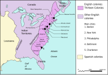
| nykyinen | 3. maaliskuuta 2023 kello 07.13 |  | 506 × 662 (507 KiB) | Johnn Francis | Reverted to version as of 21:34, 7 January 2009 (UTC) This map describes the situation in the year 1775. Florida was acquired by Britain in 1763 from Spain (who would re-acquire it in 1783). Therefore Florida (both west and east) was British at the time this map is set. |
| 19. joulukuuta 2022 kello 18.41 |  | 506 × 662 (503 KiB) | PatriaDeTodos | Florida was Spanish between 1513 and 1821 | |
| 7. tammikuuta 2009 kello 23.34 |  | 506 × 662 (507 KiB) | Cg-realms | Fixed English text | |
| 7. tammikuuta 2009 kello 23.18 |  | 506 × 662 (231 KiB) | Cg-realms | {{Information |Description={{en|1=Map of territorial growth, 1775. Adapted to vector graphics from JPG scan.}} |Source=Adapted from National Atlas of the United States scan uploaded by Kooma |Aut |
Tiedoston käyttö
Seuraavat 3 sivua käyttävät tätä tiedostoa:
Tiedoston järjestelmänlaajuinen käyttö
Seuraavat muut wikit käyttävät tätä tiedostoa:
- Käyttö sivustolla af.wikipedia.org
- Käyttö sivustolla als.wikipedia.org
- Käyttö sivustolla am.wikipedia.org
- Käyttö sivustolla ang.wikipedia.org
- Käyttö sivustolla ar.wikipedia.org
- Käyttö sivustolla arz.wikipedia.org
- Käyttö sivustolla ast.wikipedia.org
- Käyttö sivustolla azb.wikipedia.org
- Käyttö sivustolla be.wikipedia.org
- Käyttö sivustolla bg.wikipedia.org
- Käyttö sivustolla bh.wikipedia.org
- Käyttö sivustolla bn.wikipedia.org
- Käyttö sivustolla ca.wikipedia.org
- Guerra de la Independència dels Estats Units
- Tretze Colònies
- Batalles de Lexington i Concord
- Batalla de Pensacola
- Batalla de Fort Charlotte
- Batalla de Mobile
- Batalla de Yorktown (1781)
- Batalla de Saratoga
- Batalla de Bunker Hill
- Batalla de Baton Rouge (1779)
- Setge de Charleston
- Batalla de Brandywine
- Batalla de Germantown
- Batalla de Kings Mountain
- Batalla de Monmouth
- Batalla de Princeton
- Batalla de Trenton
- Batalla de Chesapeake
- Plantilla:Location map 13 Colònies
- Captura de Fort Bute
- Assimilació cultural dels amerindis dels Estats Units
- Indian Intercourse Act
- Teatre nord de la Guerra de la Revolució Americana després de Saratoga
- Teatre oest de la Guerra de la Revolució Americana
- Teatre sud de la Guerra de la Revolució Americana
- Campanya de Yorktown
- Operacions navals de la Guerra de la Revolució Americana
- Nova Escòcia a la Revolució Americana
Näytä lisää tämän tiedoston järjestelmänlaajuista käyttöä.


