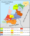
Tiedosto:Map Kingdom of Holland 1807-en.svg
Siirry navigaatioon
Siirry hakuun

Tämän PNG-esikatselun koko koskien SVG-tiedostoa: 505 × 600 kuvapistettä. Muut resoluutiot: 202 × 240 kuvapistettä | 404 × 480 kuvapistettä | 647 × 768 kuvapistettä | 862 × 1 024 kuvapistettä | 1 725 × 2 048 kuvapistettä | 1 902 × 2 258 kuvapistettä.
Alkuperäinen tiedosto (SVG-tiedosto; oletustarkkuus 1 902 × 2 258 kuvapistettä; tiedostokoko 329 KiB)
Tiedoston historia
Päiväystä napsauttamalla näet, millainen tiedosto oli kyseisellä hetkellä.
| Päiväys | Pienoiskuva | Koko | Käyttäjä | Kommentti | |
|---|---|---|---|---|---|
| nykyinen | 6. helmikuuta 2022 kello 00.16 |  | 1 902 × 2 258 (329 KiB) | Magog the Ogre | see Special:Permalink/626968493; note from User:LightPhoenix |
| 6. tammikuuta 2022 kello 14.38 |  | 1 902 × 2 258 (329 KiB) | Magog the Ogre | copyedit | |
| 4. tammikuuta 2022 kello 05.52 |  | 1 902 × 2 258 (329 KiB) | Magog the Ogre | == {{int:filedesc}} == {{Information |Description= |Source={{ef|Map_Kingdom_of_Holland_1807-es.svg}} |Date=2021-01-04 03:51 |Author={{u|Joostik}}, {{u|Magog the Ogre}} |Permission= |other_versions={{other versions/Map Kingdom of Holland 1807}} }} == {{int:license-header}} == {{self|cc-by-sa-3.0}} Category:Maps of the Kingdom of Holland Category:English-language maps showing history of Europe Category:English-language SVG maps showing history |
Tiedoston käyttö
Seuraava sivu käyttää tätä tiedostoa:
Tiedoston järjestelmänlaajuinen käyttö
Seuraavat muut wikit käyttävät tätä tiedostoa:
- Käyttö sivustolla en.wikipedia.org
- Käyttö sivustolla id.wikipedia.org
- Käyttö sivustolla ja.wikipedia.org
- Käyttö sivustolla ko.wikipedia.org
- Käyttö sivustolla mk.wikipedia.org
- Käyttö sivustolla simple.wikipedia.org
- Käyttö sivustolla sl.wikipedia.org


