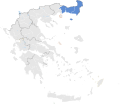
Tiedosto:Location map of Thrace (Greece).svg
Siirry navigaatioon
Siirry hakuun

Tämän PNG-esikatselun koko koskien SVG-tiedostoa: 693 × 599 kuvapistettä. Muut resoluutiot: 278 × 240 kuvapistettä | 555 × 480 kuvapistettä | 888 × 768 kuvapistettä | 1 184 × 1 024 kuvapistettä | 2 369 × 2 048 kuvapistettä | 8 460 × 7 315 kuvapistettä.
Alkuperäinen tiedosto (SVG-tiedosto; oletustarkkuus 8 460 × 7 315 kuvapistettä; tiedostokoko 1,82 MiB)
Tiedoston historia
Päiväystä napsauttamalla näet, millainen tiedosto oli kyseisellä hetkellä.
| Päiväys | Pienoiskuva | Koko | Käyttäjä | Kommentti | |
|---|---|---|---|---|---|
| nykyinen | 17. tammikuuta 2015 kello 17.43 |  | 8 460 × 7 315 (1,82 MiB) | SilentResident | Fixed outline and color differences for some Greek islands in the Ionian Sea and the Aegean Sea that could confuse the readers. |
| 17. tammikuuta 2015 kello 17.20 |  | 8 460 × 7 315 (1,82 MiB) | SilentResident | The Map has been updated to include some missing territories of Greece. | |
| 16. tammikuuta 2015 kello 21.43 |  | 7 304 × 7 315 (1,74 MiB) | SilentResident | {{Information |Description ={{en|1=The location of Thrace within Greece.}} |Source ={{own}} |Author =SilentResident,Philly boy92 |Date =2014-01-16 |Permission = |other_versi... |
Tiedoston käyttö
Seuraava sivu käyttää tätä tiedostoa:
Tiedoston järjestelmänlaajuinen käyttö
Seuraavat muut wikit käyttävät tätä tiedostoa:
- Käyttö sivustolla ar.wikipedia.org
- Käyttö sivustolla bg.wikipedia.org
- Käyttö sivustolla el.wikipedia.org
- Käyttö sivustolla en.wikipedia.org
- Käyttö sivustolla id.wikipedia.org
- Käyttö sivustolla pt.wikipedia.org
- Käyttö sivustolla sr.wikipedia.org
- Käyttö sivustolla tr.wikipedia.org
- Käyttö sivustolla ur.wikipedia.org
- Käyttö sivustolla zh.wikipedia.org
