
Tiedosto:Kingdom of Arles 1000.svg

Tämän PNG-esikatselun koko koskien SVG-tiedostoa: 485 × 340 kuvapistettä. Muut resoluutiot: 320 × 224 kuvapistettä | 640 × 449 kuvapistettä | 1 024 × 718 kuvapistettä | 1 280 × 897 kuvapistettä | 2 560 × 1 795 kuvapistettä.
Alkuperäinen tiedosto (SVG-tiedosto; oletustarkkuus 485 × 340 kuvapistettä; tiedostokoko 1,25 MiB)
| Tämä tiedosto on tiedostotietokanta Wikimedia Commonsista. Tiedot kuvaussivulta näkyvät alla. |  |
Tiedoston kuvaussivu Commonsissa |
Yhteenveto
Tämä vektorigrafiikkatiedosto luotiin käyttäen apuna ohjelmaa Inkscape .


.svg)
.svg)
.svg)
.svg)
.svg)


.svg)
.svg)
.svg)


.png)
.png)


.svg)


.svg)

.svg)


.svg)
.svg)
.svg)
.svg)


.svg)
.png)


.svg)


.svg)
.svg)


.svg)


.svg)


.svg)
.svg)
.svg)
.svg)
.svg)
.svg)
.svg)
.svg)
_cropped.svg)
.svg)
.svg)
.svg)
.svg)
.svg)
.svg)
.svg)
.svg)
.svg)
.svg)
.svg)
.svg)
.svg)
.svg)
.svg)
.svg)
.svg)
.svg)
.svg)
.svg)
.svg)
.svg)
.svg)
.svg)
.svg)
.svg)
.svg)
.svg)
.svg)
.svg)
.svg)
.svg)
.svg)
.svg)
.svg)
.svg)
.svg)
.svg)
.svg)
.svg)
.svg)
.svg)
.svg)
.svg)
.svg)
Lisenssi
Tämä tiedosto on lisensoitu Creative Commons Nimeä-JaaSamoin 4.0 Kansainvälinen -lisenssillä.
- Voit:
- jakaa – kopioida, levittää ja esittää teosta
- remiksata – valmistaa muutettuja teoksia
- Seuraavilla ehdoilla:
- nimeäminen – Sinun on mainittava lähde asianmukaisesti, tarjottava linkki lisenssiin sekä merkittävä, mikäli olet tehnyt muutoksia. Voit tehdä yllä olevan millä tahansa kohtuullisella tavalla, mutta et siten, että annat ymmärtää lisenssinantajan suosittelevan sinua tai teoksen käyttöäsi.
- jaa samoin – Jos muutat tai perustat tähän työhön, voit jakaa tuloksena syntyvää työtä vain tällä tai tämän kaltaisella lisenssillä.
Tiedoston historia
Päiväystä napsauttamalla näet, millainen tiedosto oli kyseisellä hetkellä.
| Päiväys | Pienoiskuva | Koko | Käyttäjä | Kommentti | |
|---|---|---|---|---|---|
| nykyinen | 23. toukokuuta 2016 kello 16.41 | | 485 × 340 (1,25 MiB) | Alphathon | Corrected status of Bohemia |
| 22. toukokuuta 2016 kello 20.16 |  | 485 × 340 (1,24 MiB) | Alphathon | Split Capua from Benevento and removed both from HRE, along with Spoleto | |
| 22. toukokuuta 2016 kello 18.42 |  | 485 × 340 (1,23 MiB) | Alphathon | Added Welsh kingdoms/principalities and removed Rügen from the HRE | |
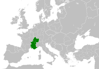
| 22. toukokuuta 2016 kello 17.39 |  | 485 × 340 (1,23 MiB) | Alphathon | == {{int:filedesc}} == {{Inkscape}} {{Information |Description={{en|A map of the Kingdom of Arles/Arelat/Burgundy within Europe circa 1000 CE. The main subdivisions of the Byzantine Empire, Holy Roman Empire, Burgundy, France a... |
Tiedoston käyttö
Seuraava sivu käyttää tätä tiedostoa:
Tiedoston järjestelmänlaajuinen käyttö
Seuraavat muut wikit käyttävät tätä tiedostoa:
- Käyttö sivustolla ast.wikipedia.org
- Käyttö sivustolla az.wikipedia.org
- Käyttö sivustolla ca.wikipedia.org
- Käyttö sivustolla cs.wikipedia.org
- Käyttö sivustolla el.wikipedia.org
- Käyttö sivustolla en.wikipedia.org
- Käyttö sivustolla eo.wikipedia.org
- Käyttö sivustolla es.wikipedia.org
- Käyttö sivustolla fa.wikipedia.org
- Käyttö sivustolla fr.wikipedia.org
- Käyttö sivustolla he.wikipedia.org
- Käyttö sivustolla hu.wikipedia.org
- Käyttö sivustolla id.wikipedia.org
- Käyttö sivustolla it.wikipedia.org
- Käyttö sivustolla it.wikiquote.org
- Käyttö sivustolla ko.wikipedia.org
- Käyttö sivustolla lv.wikipedia.org
- Käyttö sivustolla pl.wikipedia.org
- Käyttö sivustolla ro.wikipedia.org
- Käyttö sivustolla sl.wikipedia.org
- Käyttö sivustolla th.wikipedia.org
- Käyttö sivustolla uk.wikipedia.org
- Käyttö sivustolla vi.wikipedia.org
- Käyttö sivustolla www.wikidata.org
- Käyttö sivustolla zh.wikipedia.org
.svg)