Tiedosto:Hitler-Headquarters-Europe.png

Alkuperäinen tiedosto (1 120 × 790 kuvapistettä, 473 KiB, MIME-tyyppi: image/png)
| Tämä tiedosto on tiedostotietokanta Wikimedia Commonsista. Tiedot kuvaussivulta näkyvät alla. |  |
Tiedoston kuvaussivu Commonsissa |
Yhteenveto
| Kuvaus |
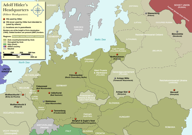
Map of Adolf Hitler's Headquarters (Führer Headquarters) in Europe 1933-1945. Countries that were part of the Axis/annexed by Axis are colored dark green (Germany, Austria, Hungary, Romania & Italy etc). |
| Päiväys | |
| Lähde | Self-made, based on information from references below |
| Tekijä | User:Dna-Dennis |
| Käyttöoikeus (Tämän tiedoston uudelleenkäyttö) |
CC, see below. The map is completely unrestricted for any Wikipedia/Wikimedia project. If you have any opinions/suggestions, please contact me here on my talk page. |
| Muut versiot |
|


.png)

|
Tämä tyyppiä historical map oleva kuva pitäisi luoda uudelleen SVG-tiedostoksi vektorigrafiikan avulla. Tällä tiedostotyypillä on monia vahvuuksia, sivulta Commons:Media for cleanup löytyy lisätietoja. Jos tästä kuvasta on jo olemassa SVG-versio, ole ystävällinen ja tallenna se tänne. SVG-tiedoston tallentamisen jälkeen vaihda tämä malline mallineeseen {{vector version available|uusi kuvan nimi.svg}}.
|
Lisenssi
- Voit:
- jakaa – kopioida, levittää ja esittää teosta
- remiksata – valmistaa muutettuja teoksia
- Seuraavilla ehdoilla:
- nimeäminen – Sinun on mainittava lähde asianmukaisesti, tarjottava linkki lisenssiin sekä merkittävä, mikäli olet tehnyt muutoksia. Voit tehdä yllä olevan millä tahansa kohtuullisella tavalla, mutta et siten, että annat ymmärtää lisenssinantajan suosittelevan sinua tai teoksen käyttöäsi.
References
- Beevor, Antony, Berlin - The Downfall 1945
- Eberle, Henrik and Uhl, Matthias, The Unknown Hitler
- Hansen, Hans-Josef: Felsennest - Das vergessene Führerhauptquartier in der Eifel. Bau, Nutzung, Zerstörung. Aachen 2006, Helios-Verlag, ISBN 3-938208-21-X.
- Kuffner, Alexander: Zeitreiseführer Eifel 1933-45. Helios, Aachen 2007, ISBN 978-3-938208-42-7.
- Raiber, Richard, Guide to Hitler's Headquarters, After the Battle archive copy at the Wayback Machine, No.19, Special Edition, Battle of Britain International Ltd, 1977, London
- Ramsey, Winston G. (editor) & Posch, Tom (researcher), The Berlin Führerbunker: The Thirteenth Hole, After the Battle archive copy at the Wayback Machine, No.61, Special Edition, Battle of Britain International Ltd, 1988, London
- von Loringhoven, Bernd Freytag/d’Alançon, François: Mit Hitler im Bunker. Aufzeichnungen aus dem Führerhauptquartier Juli 1944 – April 1945. Berlin 2005, wjs-Verlag, ISBN 3-937989-14-5.
- Schulz, Alfons: Drei Jahre in der Nachrichtenzentrale des Führerhauptquartiers. Christiana-Verlag, Stein am Rhein. 2. Aufl. 1997. ISBN 3-7171-1028-4.
- Seidler, Franz W./Zeigert, Dieter : Die Führerhauptquartiere. Anlagen und Planungen im Zweiten Weltkrieg. München: Herbig 2000. ISBN 3-7766-2154-0.
Notes on the individual headquarters
- Adlerhorst (Guide to Hitler's Headquarters, p.51)
- Anlage Mitte (Guide to Hitler's Headquarters, p.48)
- Anlage Süd (Guide to Hitler's Headquarters, p.48)
- Berghof/Eagle's nest (Guide to Hitler's Headquarters, p.2) - please note that the "Eagle's nest" was rarely used
- Bärenhöhle (www.bundesarchiv.de)
- Felsennest (Guide to Hitler's Headquarters, p.4)
- Führerbunker (After The Battle, No.61 (entire))
- Tannenberg (Guide to Hitler's Headquarters, p.18)
- Waldwiese (www.bundesarchiv.de)
- Wasserburg (www.bundesarchiv.de)
- Werwolf (Guide to Hitler's Headquarters, p.48)
- Wolfsschanze (Guide to Hitler's Headquarters, p.28)
- Wolfsschlucht I (Guide to Hitler's Headquarters, p.10)
- Wolfsschlucht II (Guide to Hitler's Headquarters, p.49)
Tiedoston historia
Päiväystä napsauttamalla näet, millainen tiedosto oli kyseisellä hetkellä.
| Päiväys | Pienoiskuva | Koko | Käyttäjä | Kommentti | |
|---|---|---|---|---|---|
| nykyinen | 3. huhtikuuta 2012 kello 11.19 | | 1 120 × 790 (473 KiB) | Asav | Wehrwolf -> Werwolf (Correct name, see "Naming" section on en.wp) |
| 20. joulukuuta 2007 kello 06.54 |  | 1 120 × 790 (537 KiB) | Dna-webmaster~commonswiki | completely new version with 1942 borders | |
| 17. joulukuuta 2007 kello 02.32 |  | 1 120 × 790 (408 KiB) | Dna-webmaster~commonswiki | updated map - please suggest changes before making any bold moves, please | |
| 10. joulukuuta 2007 kello 20.25 |  | 1 096 × 704 (37 KiB) | Matthead | Modified version, file size reduced, country coloring removed (countries as of 2007 were not involved in WW2) | |
| 21. lokakuuta 2007 kello 07.27 |  | 1 120 × 790 (407 KiB) | Dna-webmaster~commonswiki | new version with new colors | |
| 16. lokakuuta 2007 kello 17.11 |  | 1 120 × 790 (447 KiB) | Dna-webmaster~commonswiki | new version | |
| 14. lokakuuta 2007 kello 23.46 |  | 1 120 × 790 (423 KiB) | Dna-webmaster~commonswiki | quick update | |
| 14. lokakuuta 2007 kello 23.38 |  | 1 120 × 790 (425 KiB) | Dna-webmaster~commonswiki | {{Information |Description=Map of Adolf Hitler's Headquarters (Führer Headquarters) in Europe 1933-1945.<br><br> For more detailed information, please see below. |Source=Self-made |Date=October 14, 2007 |Author=[http://en.wikipedia.org/wiki/User:Dna-webm |
Tiedoston käyttö
Seuraava sivu käyttää tätä tiedostoa:
Tiedoston järjestelmänlaajuinen käyttö
Seuraavat muut wikit käyttävät tätä tiedostoa:
- Käyttö kohteessa ar.wikipedia.org
- Käyttö kohteessa ast.wikipedia.org
- Käyttö kohteessa ba.wikipedia.org
- Käyttö kohteessa bg.wikipedia.org
- Käyttö kohteessa ca.wikipedia.org
- Käyttö kohteessa cs.wikipedia.org
- Käyttö kohteessa da.wikipedia.org
- Käyttö kohteessa el.wikipedia.org
- Käyttö kohteessa en.wikipedia.org
- Käyttö kohteessa es.wikipedia.org
- Käyttö kohteessa et.wikipedia.org
- Käyttö kohteessa fr.wikipedia.org
- Käyttö kohteessa he.wikipedia.org
- Käyttö kohteessa id.wikipedia.org
- Käyttö kohteessa it.wikipedia.org
- Käyttö kohteessa ja.wikipedia.org
- Käyttö kohteessa ko.wikipedia.org
- Käyttö kohteessa ms.wikipedia.org
- Käyttö kohteessa nl.wikipedia.org
- Käyttö kohteessa no.wikipedia.org
- Käyttö kohteessa pl.wikipedia.org
Näytä lisää tämän tiedoston järjestelmänlaajuista käyttöä.