
Tiedosto:Djerba Island.jpeg

Tämän esikatselun koko: 600 × 600 kuvapistettä. Muut resoluutiot: 240 × 240 kuvapistettä | 480 × 480 kuvapistettä | 768 × 768 kuvapistettä | 1 024 × 1 024 kuvapistettä | 2 333 × 2 333 kuvapistettä.
Alkuperäinen tiedosto (2 333 × 2 333 kuvapistettä, 3,86 MiB, MIME-tyyppi: image/jpeg)
| Tämä tiedosto on tiedostotietokanta Wikimedia Commonsista. Tiedot kuvaussivulta näkyvät alla. |  |
Tiedoston kuvaussivu Commonsissa |
Yhteenveto
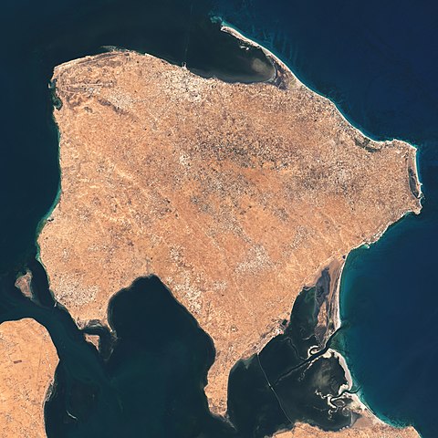
| Kuvaus | The Operational Land Imager (OLI) on Landsat 8 acquired these natural-color images of Ajim on May 4, 2020. |
| Päiväys | |
| Lähde | https://earthobservatory.nasa.gov/images/146772/a-falcon-over-ajim |
| Tekijä | NASA Earth Observatory images by Lauren Dauphin, using Landsat data from the U.S. Geological Survey. Story by Adam Voiland. |
Lisenssi
| Tämä teos on ilman tekijänoikeuden suojaa, koska National Aeronautics and Space Administration (NASA) loi sen. Koska Nasa on Yhdysvaltain liittovaltion organisaatio, sen luomat teokset ovat ilman tekijänoikeuden suojaa. ([1][2]) | ||
 |
Varoitukset:
|
Tiedoston historia
Päiväystä napsauttamalla näet, millainen tiedosto oli kyseisellä hetkellä.
| Päiväys | Pienoiskuva | Koko | Käyttäjä | Kommentti | |
|---|---|---|---|---|---|
| nykyinen | 26. toukokuuta 2021 kello 04.39 | | 2 333 × 2 333 (3,86 MiB) | StellarHalo | {{Information |Description=The Operational Land Imager (OLI) on Landsat 8 acquired these natural-color images of Ajim on May 4, 2020. |Source=https://earthobservatory.nasa.gov/images/146772/a-falcon-over-ajim |Date=4 May 2020 |Author=NASA Earth Observatory images by Lauren Dauphin, using Landsat data from the U.S. Geological Survey. Story by Adam Voiland. |Permission= |other_versions= }} Category:Satellite pictures by Landsat 8 Category:Satellite pictures of Tunisia Category:Djerba |
Tiedoston käyttö
Seuraava sivu käyttää tätä tiedostoa:
Tiedoston järjestelmänlaajuinen käyttö
Seuraavat muut wikit käyttävät tätä tiedostoa:
- Käyttö sivustolla en.wikipedia.org
- Käyttö sivustolla fr.wikipedia.org
- Käyttö sivustolla pl.wikipedia.org
- Käyttö sivustolla si.wikipedia.org
- Käyttö sivustolla th.wikipedia.org
- Käyttö sivustolla www.wikidata.org