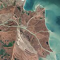
Tiedosto:Danubedelta chilia lobe satellite image.jpg
Siirry navigaatioon
Siirry hakuun

Tämän esikatselun koko: 600 × 600 kuvapistettä. Muut resoluutiot: 240 × 240 kuvapistettä | 480 × 480 kuvapistettä | 768 × 768 kuvapistettä | 1 024 × 1 024 kuvapistettä | 2 048 × 2 048 kuvapistettä | 3 679 × 3 679 kuvapistettä.
Alkuperäinen tiedosto (3 679 × 3 679 kuvapistettä, 3,95 MiB, MIME-tyyppi: image/jpeg)
Tiedoston historia
Päiväystä napsauttamalla näet, millainen tiedosto oli kyseisellä hetkellä.
| Päiväys | Pienoiskuva | Koko | Käyttäjä | Kommentti | |
|---|---|---|---|---|---|
| nykyinen | 5. heinäkuuta 2014 kello 00.10 |  | 3 679 × 3 679 (3,95 MiB) | Gretarsson | {{Information |Description ={{en|1=Original image caption (excerpt): The image above was acquired on February 5, 2013, by the Advanced Land Imager (ALI) on NASA’s Earth Observing-1 (EO-1) satellite. The Danube Delta has a number of lobes formed ov... |
Tiedoston käyttö
Seuraava sivu käyttää tätä tiedostoa:
Tiedoston järjestelmänlaajuinen käyttö
Seuraavat muut wikit käyttävät tätä tiedostoa:
- Käyttö sivustolla cy.wikipedia.org
- Käyttö sivustolla da.wikipedia.org
- Käyttö sivustolla de.wikipedia.org
- Käyttö sivustolla fa.wikipedia.org
- Käyttö sivustolla ja.wikipedia.org
- Käyttö sivustolla mk.wikipedia.org
- Käyttö sivustolla ru.wikipedia.org
- Käyttö sivustolla sl.wikipedia.org
- Käyttö sivustolla ta.wikipedia.org
- Käyttö sivustolla th.wikipedia.org
- Käyttö sivustolla uk.wikipedia.org
- Käyttö sivustolla vi.wikipedia.org


