Tiedosto:1870 Vaux and Olmstead Map of Central Park, New York City - Geographicus - CentralPark-knapp-1870.jpg
Alkuperäinen tiedosto (6 000 × 1 705 kuvapistettä, 2,47 MiB, MIME-tyyppi: image/jpeg)
| Tämä tiedosto on tiedostotietokanta Wikimedia Commonsista. Tiedot kuvaussivulta näkyvät alla. |  |
Tiedoston kuvaussivu Commonsissa |
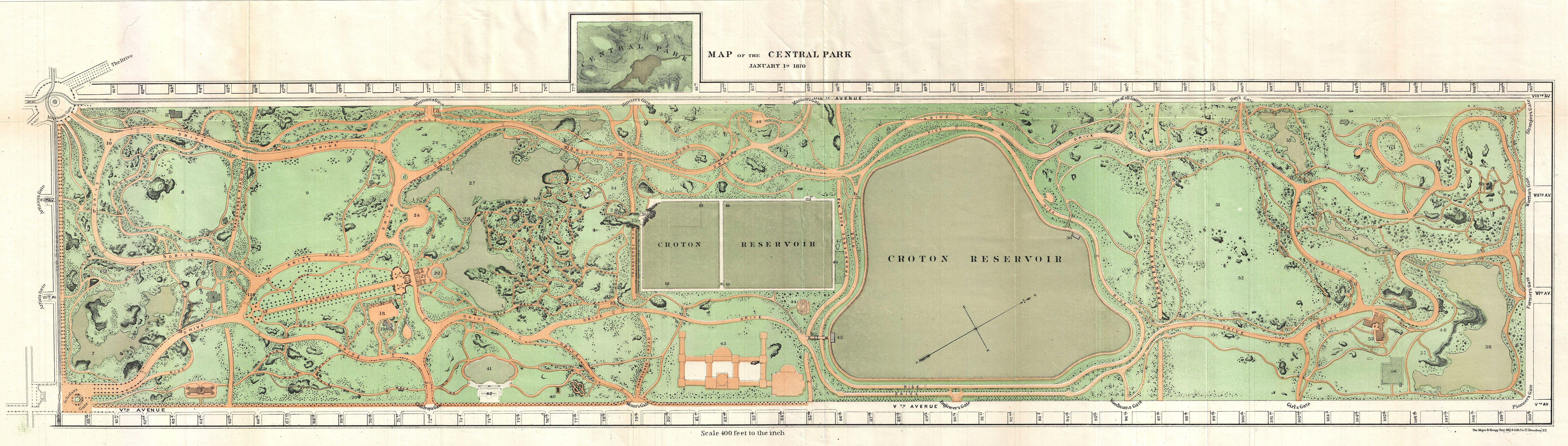
| Map of the Central Park January 1st 1870. | ||||||
|---|---|---|---|---|---|---|
| Taiteilija | ||||||
| Otsikko |
Map of the Central Park January 1st 1870. |
|||||
| Kuvaus |
English: An altogether extraordinary hand colored map of New York City’s Central Park prepared and printed for inclusion in the Thirteenth Annual Report of the Board of Commissioners of the Central Park. This is an extremely rare variant on the map of Central Park that originally appeared in the 1862 Commissioner’s Report. Depicts the park as a whole and includes pathways, lakes, buildings, individual trees, rocks, and elevation measurements. The streets and avenues surrounding the park as well as the tramways that existed at the time are also noted. This extraordinary map reveals Central Park as conceived by the Landscape Architects, and indeed “artists”, Vaux and Olmstead. Vaux and Olmstead were awarded the task of designing Central Park in 1853 by the City Common Council. Olmstead’s vision drove the overall design while Vaux concentrated his attentions on bridges, buildings, and other structures within the park. The creation of Central Park, which was to consist of some 800 acres of public forest, pathways, promenades, lakes, bridges, and meadows, was a seminal moment in civic urban design. The park itself was designed as a whole with every tree, pond, and bench meticulously planned. Olmstead wrote: “Every foot of the parks surface, every tree and bush, as well as every arch, roadway, and walk and been placed where it is for a purpose.” Historian Gloria Deak writes, “There was a staggering amount of work to be done to transform the area into a blend of pastoral and woodland scenery. This involved the design and construction of roadways, tunnels, bridges, arches, stairways, fountains, benches, lamp posts, gates, fences and innumerable other artifacts. It also involved the supervision of an army of about five thousand laborers…Olmsted, to whom most of the credit goes, insisted on seeing the multidimensional project as a single work of art, which he was mandated to create. For this purpose, he ventured to assume to himself the title of ‘artist.’” Today, because of Vaux and Olmstead’s efforts, New York Yorkers, ourselves included, have the privilege of enjoying what is, perhaps, the finest example of a planned urban public recreation area in the world. |
|||||
| Päiväys | 1870 (dated) | |||||
| Mitat | korkeus: 10 in (25,4 cm); leveys: 35,5 in (90,1 cm) | |||||
| Tunniste |
Geographicus link: CentralPark-knapp-1870 |
|||||
| Lähde/Valokuvaaja |
Thirteenth Annual Report of the Commissioners of the Central Park, (New York) 1870.
|
|||||
| Käyttöoikeus (Tämän tiedoston uudelleenkäyttö) |
|
|||||
Tiedoston historia
Päiväystä napsauttamalla näet, millainen tiedosto oli kyseisellä hetkellä.
| Päiväys | Pienoiskuva | Koko | Käyttäjä | Kommentti | |
|---|---|---|---|---|---|
| nykyinen | 25. maaliskuuta 2011 kello 10.18 | 6 000 × 1 705 (2,47 MiB) | BotMultichillT | {{subst:User:Multichill/Geographicus |link=http://www.geographicus.com/P/AntiqueMap/CentralPark-knapp-1870 |product_name=1870 Vaux and Olmstead Map of Central Park, New York City |map_title=Map of the Central Park January 1st 1870. |description=An altoget |
Tiedoston käyttö
Seuraava sivu käyttää tätä tiedostoa: